Wednesday, July 27, 2016

Ft. Sanders, Wyoming.


This is one of the more disappointing items I've posted here, as the location itself is disappointing.  This is the site of the former Ft. Sanders, Wyoming, just outside of Laramie Wyoming


Ft. Sanders isn't a fort we think of much in terms of Frontier, or Wyoming, history.  It was a small post along the Union Pacific, and as such it seemingly figured in the story of the Indian Wars less than some others we'd typically consider.  This doesn't mean it wasn't a significant post in its own way, but it wasn't a major post like Ft. Laramie, nor was it one that was on the ragged edge of the Indian frontier, like Ft. Caspar or Ft. Reno.


And there's very little left of it. As the Wyoming sign commemorating it notes, the mostly wooden post is now mostly gone.  The brick building above was the powder magazine.  I couldn't spot the guard house when I was there, but I understand it to still exist, and to be across the highway, so I'll have to update this entry once I find it.  The sign is somewhat inaccurate as apparently some structures that were on the post were moved into Laramie for private use and still exist, and The Cavalryman Restaurant, depicted in the photograph above, was a post structure.


Tuesday, July 26, 2016

Abraham Lincoln Memorial, Interstate 80, Wyoming


This is the very large bronze of Abraham Lincoln located on Interstate 80 just east of Laramie, Wyoming.  Interstate 80 is located on what was once the Lincoln Highway, hence explaining the very large bronze, which is otherwise somewhat unusual for a Wyoming monument.

Saturday, July 16, 2016

Crowheart Butte, Wyoming


This is a bit of an unusual roadside monument in the West as it doesn't commemorate a battle between European Americans and Indians, but rather between two separate tribes if Indians.  It commemorates the March 1866 battle between the Shoshone and Crows near the Wind River Range in Wyoming.


The date, and the event, are interesting ones.  By 1866 warfare between the United States and the combined Sioux and Cheyenne had broken out in earnest.  The Crows were fighting the Sioux and had been for quite some time.  Indeed, they were fighting a loosing battle in their war with the Sioux and had offered to throw in with the United States in aid that effort.  Ironically, the Shoshone were allies of the United States.


Both the Shoshone and the Crows were under tremendous pressure from the Sioux and Cheyenne, who had been expanding out onto the territory that had formerly belonged to those tribes. The Crows in particular had suffered a tremendous territorial loss in that they had been pushed out of the prairie region of Wyoming for the most part by that time but they were still attempting to contest for it.  The Shoshone had also suffered a territorial loss but, with their anchor in the Wind Rivers, which the Sioux had not yet reached, their situation was not as dire.


Nonetheless, we see how these factors can play out in odd ways. Both tribes were here essentially defending their traditional grounds. The Crows could hardly afford to loose any more of theirs as they'd already lost so much.  Nonetheless, as can be seen here, they were defeated in this battle and they would in fact go on to have to accept the loss of much of what they had formerly controlled.


The Shoshones were already looking at asking for a reservation at the time this battle took place and even though this ground had been already assigned to the Crows by treaty.  The Crows were effectively defeated by the Shoshone in the area and Crowheart Butte became part of the Shoshone Reservation very shortly thereafter.

The text of this roadside monument makes it quite clear that this sign was made quite some time ago, probably in the 1950s.  The text that is on it would never be placed on a monument today, in that the partisan language regarding "whites" would simply not be done.  Indeed, in many instances such signs tend to get removed.  At least one old historical marker in New Mexico has had some of the text chipped out in order to edit it, and at least one of these road side markers in Wyoming that had somewhat similar content has been removed.  That's a shame, as in editing to fit our current definition of history, we in fact do a little injustice to the story of history itself by removing the evidence of how things were once perceived.

Tie Hack Memorial, Shoshone National Forest, Wyoming


This memorial to tie hacks is located about twelve miles north of Dubois Wyoming along the state highway. The scenery nearby is quite spectacular.

Green River Rendezvous Site, Sublette County Wyoming.


Really off topic here, and more deserving to be on one of our other blogs such as Today In Wyoing's History, this is the Sublette County Museum Board's marker for the site of the Green River Rendezvous.

Split Rock, Wyoming


Sunday, June 26, 2016

Roads to the Great War: Father Duffy: Why Was He Beloved?

Roads to the Great War: Father Duffy: Why Was He Beloved?: At Times Square New York Father Francis Duffy was the chaplain of New York's 69th Infantry, which fought in France as the 165t...

Lex Anteinternet: What Are You Reading?

Over on our most active blog, Lex Anteinternet: What are you reading?:

What are you reading?


A new trailing thread, dedicated to what we're currently reading.

And. . . we hope. . . with participation from you.

What are you reading right  now? Add it down in the commentary section
__________________________________________________________________________________

June 21, 2016

Give Me Eighty Men

I'm presently reading Give Me Eighty Men by Shannon Smith. It's a history of the Fetterman Fight, and a history of the history of the Fetterman Fight. I'll review it when I'm done, but I'll note that the favorable mention of the book by the authors of The Heart of All That Is caused me to pick it up, even though I'd been inclined to previously avoid it.

So far, I'm enjoying it, and its certainly raising a lot questions in my mind about the Fetterman battle, although I'm reserving my judgment on various things so far.
Stop over and let us know what you're reading!

That thread:  What Are You Reading?

Friday, June 24, 2016

Lex Anteinternet: Welcome Home PFC Harold Schultz, USMC

Lex Anteinternet: Welcome Home PFC Harold Schultz, USMC: All these years, PFC Schultz, who is one of the flag raisers on the iconic Rosenthall photograph and the USMC Ogg film of the raising of ...

Wednesday, May 25, 2016

WHEELS THAT WON THE WEST®: Memorial Day 2016

WHEELS THAT WON THE WEST®: Memorial Day 2016: For many, this coming weekend will offer a respite of sorts; a time to enjoy activities with family and friends, do a little traveli...

Saturday, May 14, 2016

Mormon Battalion Monument, Salt Lake City Utah.


If there's a photo that gives a worse depiction of a monument on this page than this one, I don't know what it is.

However, as a business traveler, and having seen this for the first time, and not knowing when I'll have the opportunity to photograph it again, here's an early morning photograph of the monument to the Mormon Battalion of the Mexican War on the grounds of Utah's capitol.  

The unit is unique in that its probably the only religiously based unit to have ever served in US service, although there are other units that can claim to be religiously homogeneous.  The unit was raised in a period of extreme tension between the Mormons, which were in the process of relocating to the Salt Lake Valley, and the United States.   The thought was that the raising of the volunteer unit would help dispel that.  

The unit was raised and did march a very long way to campaign in the war, but it did not see much in the way of actual combat, which is not to say that it did not see any.  The monument to the unit is being renovated, and as a result, this photograph only shows that a monument exists, without really given any details.

Thursday, April 7, 2016

World War One, World War Two, and Korean War Memorial: Chugwater Wyoming


This is the memorial for men lost in World War One, World War Two and the Korean War from the tiny town of Chugwater, Wyoming.  Chugwater is a very small town in Platte County, although it was probably a little larger during the Great War, World War Two, and the Korean War.

Expressing a unique tragedy, the same name appears on this memorial twice, but as that name was very clearly added for a serviceman of the Korean War after the monument was placed, we would have to assume that this represents two servicemen of the same name, likely father and son.

The memorial is located in a very small park across from the town hall.  Oddly, two figures have been added relatively recently which depict current servicemen, carrying M4 carbines. The figures are out of place and sort of resemble the plastic toy soldiers that kids play with and are an unfortunate addition to the memorial.

Sunday, March 13, 2016

Sweetwater County World War One Memorial, Bunning Park, Rock Springs Wyoming


This is the World War One monument in Rock Springs Wyoming. Dedicated to the Sweetwater County fallen in the war, it is located in Bunning Park, which was dedicated by a mayor of the city for which the park is named.  Perhaps somewhat ironically, Peter  Bunning was German by birth and had served in the German army before immigrating to Denmark, and then on to the United States, where he became a highly successful Sweetwater County businessman.
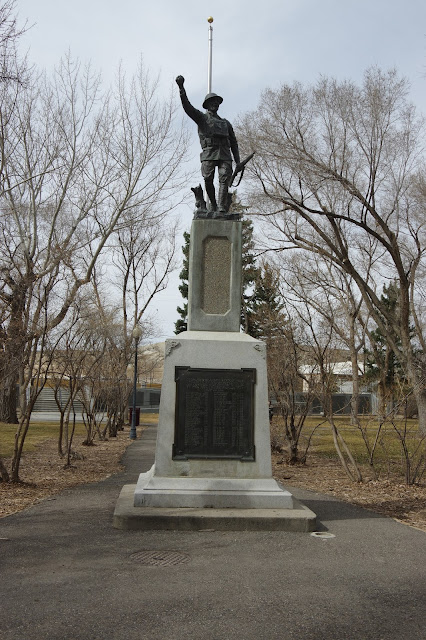
The doughboy statue itself is of a design that was widely manufactured following the First World War for memorials.

It can't help be noted that there are a surprisingly large number of names on this memorial, given the short amount of time that the United States had troops in action during the Great War, and given that Sweetwater County's population would not have been large.

Saturday, March 12, 2016

The Parting of the Ways


These monuments, within about 100 yards of each other, commemorate the Oregon Trail and the Parting of the Ways, that spot where the Oregon and California Trails diverged.  Unfortunately, as the informational sign makes clear, the monument is in the wrong place.  The actual Parting of the Ways is about ten miles to the west.