This monument is placed at the same rest stop that the Lincoln Memorial and the Lincoln Highway Memorial featured below are located. It's obviously in honor of those who have been wounded in action, and therefore eligible to receive the Purple Heart.
Pages
▼
Wednesday, July 27, 2016
Henry B. Joy Memorial, Interstate 80, Albany County Wyoming.
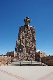
This is a monument to one of the founders of the Lincoln Highway, located along its successor, Interstate 80. The art deco memorial was created in 1938, the "L" cement markers are markers for the Lincoln Highway that can be found here and there along its route.
While this blog started out with war memorials, it's covered quite a few trail markers over the years, and indeed I will now be adding that as a category here, meaning I have to go back and edit quite a few old posts. This marker, however, is only the second one I've posted on any of my blogs to highways, the other being the Black and Yellow Road near Gillette.
This marker is quite elaborate and very nice, being both a suitable marker for the Lincoln Highway and a nice example of an art deco piece of art.
Wyoming has also commemorated the highway, the noted individual, and the marker, with its own highway sign.
All of this is located at the same rest stop on Albany County that the Lincoln Memorial is located at. Of note, this marker was moved from its original location, which might have been one that was preferred by the individual commemorated by the marker.
The Overland Trail, Albany County Wyoming
These are two markers noting the location, in Albany County, where the Overland Trail passed by the current town of Laramie.
The Overland Trail was a southern bypass, basically, on the Oregon Trail, taking immigrants and travelers considerably further south and therefore also out of the more active areas on the Platte that saw a lot of Indian activity. The Overland Trail was not safe, but it was less likely to see Indian hostilities.
We tend to think, today, only of the Oregon Trail, but this markers serves to remind us that pioneers took a variety of routes. This one later was exploited, roughly, by the Union Pacific railroad which took a somewhat analogous route for much of its course.
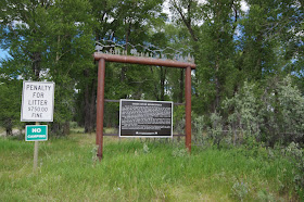
This location interestingly features at least three, and maybe four, generations of Wyoming highway historical markers. The large wooden sign is a common one still used by Wyoming today. A new paper sign with a bar code has been added to this and several other monuments in Albany County, suggesting that the state has some sort of new program going on.
This area, however, also features an older cement marker. I'm not terribly familiar with this type, so if anyone can add details about it, I'd appreciate it. Note the circled K on the monument.
This cement markers is just off the highway easement and I suspect that it is also associated with the trail. In much of Wyoming the Oregon Trail is marked with cement markers in its course, and I suspect that this is something similar, but older, for the Overland Trail.
Ft. Sanders, Wyoming.
This is one of the more disappointing items I've posted here, as the location itself is disappointing. This is the site of the former Ft. Sanders, Wyoming, just outside of Laramie Wyoming
Ft. Sanders isn't a fort we think of much in terms of Frontier, or Wyoming, history. It was a small post along the Union Pacific, and as such it seemingly figured in the story of the Indian Wars less than some others we'd typically consider. This doesn't mean it wasn't a significant post in its own way, but it wasn't a major post like Ft. Laramie, nor was it one that was on the ragged edge of the Indian frontier, like Ft. Caspar or Ft. Reno.
And there's very little left of it. As the Wyoming sign commemorating it notes, the mostly wooden post is now mostly gone. The brick building above was the powder magazine. I couldn't spot the guard house when I was there, but I understand it to still exist, and to be across the highway, so I'll have to update this entry once I find it. The sign is somewhat inaccurate as apparently some structures that were on the post were moved into Laramie for private use and still exist, and The Cavalryman Restaurant, depicted in the photograph above, was a post structure.
Tuesday, July 26, 2016
Abraham Lincoln Memorial, Interstate 80, Wyoming
This is the very large bronze of Abraham Lincoln located on Interstate 80 just east of Laramie, Wyoming. Interstate 80 is located on what was once the Lincoln Highway, hence explaining the very large bronze, which is otherwise somewhat unusual for a Wyoming monument.
Saturday, July 16, 2016
Crowheart Butte, Wyoming
This is a bit of an unusual roadside monument in the West as it doesn't commemorate a battle between European Americans and Indians, but rather between two separate tribes if Indians. It commemorates the March 1866 battle between the Shoshone and Crows near the Wind River Range in Wyoming.
The date, and the event, are interesting ones. By 1866 warfare between the United States and the combined Sioux and Cheyenne had broken out in earnest. The Crows were fighting the Sioux and had been for quite some time. Indeed, they were fighting a loosing battle in their war with the Sioux and had offered to throw in with the United States in aid that effort. Ironically, the Shoshone were allies of the United States.
Both the Shoshone and the Crows were under tremendous pressure from the Sioux and Cheyenne, who had been expanding out onto the territory that had formerly belonged to those tribes. The Crows in particular had suffered a tremendous territorial loss in that they had been pushed out of the prairie region of Wyoming for the most part by that time but they were still attempting to contest for it. The Shoshone had also suffered a territorial loss but, with their anchor in the Wind Rivers, which the Sioux had not yet reached, their situation was not as dire.
Nonetheless, we see how these factors can play out in odd ways. Both tribes were here essentially defending their traditional grounds. The Crows could hardly afford to loose any more of theirs as they'd already lost so much. Nonetheless, as can be seen here, they were defeated in this battle and they would in fact go on to have to accept the loss of much of what they had formerly controlled.
The Shoshones were already looking at asking for a reservation at the time this battle took place and even though this ground had been already assigned to the Crows by treaty. The Crows were effectively defeated by the Shoshone in the area and Crowheart Butte became part of the Shoshone Reservation very shortly thereafter.
The text of this roadside monument makes it quite clear that this sign was made quite some time ago, probably in the 1950s. The text that is on it would never be placed on a monument today, in that the partisan language regarding "whites" would simply not be done. Indeed, in many instances such signs tend to get removed. At least one old historical marker in New Mexico has had some of the text chipped out in order to edit it, and at least one of these road side markers in Wyoming that had somewhat similar content has been removed. That's a shame, as in editing to fit our current definition of history, we in fact do a little injustice to the story of history itself by removing the evidence of how things were once perceived.
Tie Hack Memorial, Shoshone National Forest, Wyoming
This memorial to tie hacks is located about twelve miles north of Dubois Wyoming along the state highway. The scenery nearby is quite spectacular.
Green River Rendezvous Site, Sublette County Wyoming.
Really off topic here, and more deserving to be on one of our other blogs such as Today In Wyoing's History, this is the Sublette County Museum Board's marker for the site of the Green River Rendezvous.


